Tuesday, March 24, 2015

HOME


Questions on my blog:
     Are you done contemplating on which to places you want to visit?
    Well, We will tour you to the different places in the Philippines.
       The Philippines is an archipelago in Southeast Asia made up of over 7000 islands. Beaches, volcanoes and wildlife are among the attractions that tempt tourists to the country.
       If you have hard time choosing what places to be visit, let me help you with the list icons. Just click it. Enjoy..


Mt. Iglit Baco


Mt. Iglit Baco 


         The Mts. Iglit Baco National Park was proclaimed in 1970. As such, it is an initial component of National Integrated Protected Areas System. Mts. Iglit Baco National Park encompasses at least eight major river systems and has a rugged terrain composed of slopes, river gorges and plateaus.
          Portions of the Park are covered by upland hardwoods, such as Anthocephalus chinensis, Artocarpus blancoi, Ficus nota, Hawili, Alibangbang and Balinghasai. The larger plants indigenous to the site which are rarely seen in some other regions are Kalantas tree, Tindalo, Almaciga and Kamagong. The Park also harbors the endangered Jade vine.               The Park is the habitat of the endemic Tamaraw ( Bubalus mindorensis ), which is one of the most seriously endangered large mammals. Because of the endangered Tamaraw, the Park was initially established as " game refuge and bird sanctuary ". The Park has been declared as an ASEAN Heritage Site. Other forms of wildlife can also be found in the Park like the Phil Deer, Wild Pig and Mindoro Cloud Rat as well as a number of bird species which are endemic to the island such as Mindoro Imperial Pigeon, Mindoro Scops Owl, Black-hooped Coucal, Scarlet collared Flowerpecker and Heart Pigeon.          Mount Iglit Baco National Park covers large areas of the central part of the island of Mindoro on the Philippines. It is situated near Mt. Baco ( 2,488 meters ) and Mt. Iglit, the latter reaching 2,364 meters. Unfortunately, the island is among the most deforested parts of the archipelago. Less than 3% of primary forests have been preserved there. Remnants of lowland rain, mountain and cloud forests with critically threatened endemic animal species are protected in the national park.        Under the Wild Population and Habitat Management component, scope of activities include protection of the Tamaraw and its habitats in Mts. Iglit Baco National Park and Aruyan Sablayan Tamaraw reservation; manning of entry exit points.  Tamaraw population study and biodiversity monitoring. Future activities will include habitat restoration and expansion of protection and research activities by covering other important areas maintaining Tamaraw.

Magellan's Cross Monument Cebu City


Magellan's Cross Monument Cebu City


       Magellan's Cross is a Christian cross of the Catholic faith which is housed in a small chapel in old Cebu City on Magallanes street close to the Basiclica Minore del Santo Nino [ doll of the Baby Jesus ] and not far from San Pedro Fort and Cebu Metroplitan Cathedral. '' Magallanes '' is Spanish for Magellan. It is a promoted tourist attraction because to the Cebuano it and their religion is important to them.
      The history is that when Ferdinand Magellan first arrived in Cebu on 21 April 1521 he erected a cross in Cebu. The cross there today is not the original. Magellan's Cross is one symbol of Cebu. This chapel's image can be found in Cebu city seal. It is also seen as the symbol of Roman Catholicism in the Philippines.
      Magellan and his crew were the first Europeans to arrive in the Philippines. They made the first conversions to Catholicism when they converted Rajah Humabon, the local chief, his wife and hundreds of his Cebuano villagers to accept Christianity and be consequently baptized. 
      At the same time Magellan left in Cebu the Santo Nino de Cebu [ holy child of Cebu ] a doll figure made in Europe in the 16th Century representing Jesus Christ as a child. This doll was rediscovered some 45 years later upon the return to Cebu of Miguel Lopez de Legazpi who came back to Cebu on the order of King Phillip of Spain to make Cebu the first center of the new Spanish Colony in Asia, called ''Las Islas Filipinas''. This doll also plays an important function in the religious life of millions of people as explained here.

Britannia Islands

Britannia Islands


       Britannia Group of Islands is composed of 24 islets beautifully scattered in Lianga Bay. It is located in Barangay Britannia of San Agustin, Surigao del Sur. The group of islands is like a small version of the 100 islands of Pangasinan.

Panglao Island

Panglao Island


    Panglao Island is generally associated with Alona Beach, a congested strip of resorts and dive centres on the southern side of the island. With a few exceptions, lodging and especially food is overpriced on Alona. That said, the underwater scene around Alona is indeed exceptional, and divers can score nifty package deals by combining dives with accommodation. Alona also has some decent nightlife. Just 15km fromTagbilaran, it
Read more: http://www.lonelyplanet.com/philippines/the-visayas/panglao-island#ixzz3VI5fFpkP

Maria Cristina Falls

Maria Cristina Falls


        Maria Cristina Falls is a waterfall of the Agus River on the island of Mindanao. It is sometimes called the "twin falls" as the flow is separated by a rock at the brink of the waterfall. It is a landmark of Illigan City, nicknamed the City of Majestic Waterfalls, because of the presence of more than 20 waterfalls in the city. It is located 9.3 kilometers away southwest of the city proper at the boundaries of Barangay Maria Cristina, Ditucalan, and Buru-un. Well known for its natural beauty and grandeur, the 320 - feet (98 meters) high waterfall is also the primary source of electric power for the city's industries, being harnessed by the Agus VI Hydroelectric Plant.[4]

Cebu


Cebu Dive & Adventure Travel - Scuba Diving, Dive Safaris & Live-aboards in the Philippines

dive cebu - scuba diving cebu


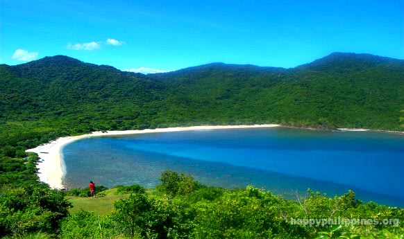
     Cebu is the traveler's fantasy of a tropical island come true - balmy weather, pristine beaches, crystalline waters, and luxurious resorts with all the frills of modern living.

     The island-province of Cebu was where the Portuguese navigator Ferdinand Magellan planted the Cross of Christianity in the name of Spain in 1521. But even before Cebu became the Occidental gateway to the Orient, it was already a popular entry point among Asian merchants.

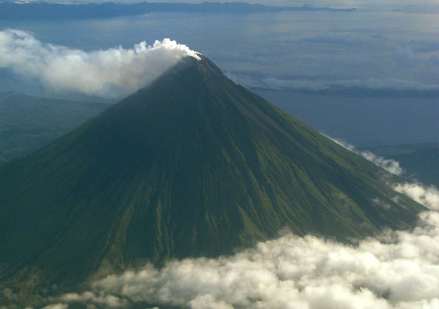
     Cebu has since blossomed into a choice tourist destination, with many leisure establishments taking full advantage of its sea-valley-and-mountain location. 

     Metropolitan Cebu, the country's second biggest metropolis, is the political, economic, educational and cultural center of the Visayas. Hotels, shopping malls, entertainment halls, casinos and golf fairways are ever present in the metro to cater to every tourist's whim.

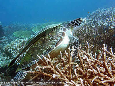
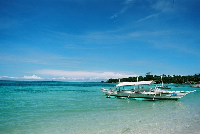
    The rest of Cebu's 166 islands and islets are fringed with sandy beaches and sapphire-clear waters teeming with marine life, perfect for divers.


Monday, March 23, 2015

Coron- Palawan

                      Coron- Palawan


              Coron is both the name of the largest town on the island of Busuanga, and the name of a different, smaller island just offshore. The area is famous for its World War II wreck diving, and the site has been named in many lists of top dive spots in the world. In September 1944, a fleet of Japanese ships hiding in the harbor were sunk in a daring raid by the US navy. The result is around ten well preserved underwater shipwrecks surrounded with coral reef.       There are also attractions on Coron Island itself. There are many beautiful bleach white sand beaches, mostly tiny and surrounded by large limestone cliffs and wildlife. Barracuda and Kayangan lakes are both stunning locations, and good for snorkeling, and the island is the ancestral domain of an indigenous tribe who are managing the island in a sustainable way and keeping outsiders at a distance and offshore at night.

Palaui Island

                               Palaui Island


      Palaui Island is made up of volcanic debris, lying between the South China Sea and the Pacific Ocean. It is a protected area having been declared as National Marine Reserve in 1994, abundant in wildlife, marine life and timber. With only a small community living in the island, it is largely uninhabited. It is politically under the jurisdiction of Sta. Ana and it is home to a small fishing community. Palaui Island has no electricity, nor commercial accommodation. Its main attraction aside from the gorgeous beaches is the 18th century lighthouse built by the Spaniards called Farol de Cabo Engaño or Cape Engaño Lighthouse. From this lighthouse, the best view of Palaui Island is offered.

Mt. Apo

                                             Mt. Apo


Mount Apo is a large solfataric, potentially-active stratovolcano in the island.       With an altitude of 3,146 metres (10,321.5 ft), Mt. Apo is the highest mountain in the country and is located between Davao City, Davao del Sur province and Cotabato province.       The peak overlooks Davao City 45 kilometres (25 mi) to the northeast, Digos City 25 kilometres (16 mi) to the southeast, and Kidapawan City 20 kilometres (12 mi) to the west.        Mt. Apo possesses a formidable array of landscapes, from craggy rockscapes to virgin forests; from mossy swamps to volcanic structures. The mountain possesses the widest spectrum of environments, and provides an experience for mountaineers that lives up to their expectations from the country’s highest.


Mayon Volcano

                       Mayon Volcano

Mayon Volcano


          Mayon, the most famous of the active volcanoes of the Philippines, is a perfect stratovolcano rising to 2462 m on Luzon Island. It erupts very frequently.     

          Mayon is the archetype of a symmetrical stratovolcano and one of the world most active ones. It has frequent eruptions producing pyroclastic flows, mud flows and ash falls that repeatedly triggered large-scale evacuations. Mayon's most violent eruption, in 1814, killed more than 1200 people and devastated several towns.     The volcano rises 2462 m above the Albay Gulf and has very steep upper slopes averaging 35-40 degrees capped by a small summit crater. Historical records of eruptions date back to 1616 and range from strombolian to basaltic plinian, with cyclical activity beginning with basaltic eruptions, followed by longer term andesitic lava flows. Eruptions occur predominately from the central conduit and have also produced lava flows that travel far down the flanks. Pyroclastic flows and mudflows have commonly swept down many of the approximately 40 ravines that radiate from the summit and have often devastated populated lowland areas. 

Puerto Galera- Oriental, Mindoro

                    Puerto Galera- Oriental, Mindoro


     Puerto Galera is the northwesternmost municipality in the province of Oriental Mindoro, Philippines. It is located at the southwestern end of the Isla Verde, about 130 kilometers (81 mi) south of Manila.Just south of Manila is the charming coastal town of Puerto Galera, well-favored for its gorgeous beaches, excellent diving spots and wide diversity of marine species. The most popular beaches are White Beach and Sabang Beach, which also offer nearby shopping, dining, nightlife and hotel accommodation. Another popular attraction is the natural harbor of Muelle Bay with its rows of shops, restaurants and bars. Visitors can also go snorkeling to see some of Asia’s best coral reefs or dive among old shipwrecks and hundreds of fish species.

Donsol-Philippines


Donsol-Philippines

Donsol


         For almost last three years in Philippines, I was waiting eagerly to get an opportunity to go for watching “Whale Sharks”. This Easter holidays provided just the right opportunity as it is the peak season for this activity.Donsol, a small coastal fishing town, 600Km away from Manila, on the southwest coast of Luzon, Philippines is frequented for several years by Whale Sharks, called “Butanding” in local Filipino dialect. All local fishermen were aware of them but it was like a best kept secret.
      A team of foreign divers publicized it for the first time in year 1998. After that, poachers and hunters swarmed this place. Filipino government stepped in quickly and declared this variety of fish as a protected species.
       Butandings, although called as Whales are not mammals like other whales but they are actually fish and belong to group of sharks. However, this one is not a predator like other varieties of sharks and just feeds on the plankton and small fish. Thus, in a sense a giant vegetarian fish. 
      The meaning of this Filipino term “Butanding” means “Gentle Giants”. This name represents their true nature. This is the largest fish in the world and grows up to the length of 60 ft and weighs up to 15 Metric Tons!! The lengths up to 50 ft are found in Donsol region. 

Malapascua Island

                                  Malapascua Island

Malapascua Island


        Malapascua Island is a Philippine island situated in the Visayan Sea, 6.8 kilometres (4.2 mi) across a shallow strait from the northernmost tip of Cebu Island. Administratively, it is part of the insular barangay of Logon, Daanbantayan,Cebu. Malapascua is a small island, only about 2.5 by 1 kilometre (1.55 by 0.62 mi), and has eight hamlets.  Malapascua became famous fairly recently, only in the early 1990s as a dive destination. Prior to this, the island was known for its wide white sand beach, known as Bounty Beach; it has also become known for its beautiful coral gardens and excellent local dive spots, as well as further-out sites including Gato Island, Monad Shoal, and Kemod Shoal. Monad Shoal is an underwater plateau where thresher sharks and manta rays can regularly be sighted.    

         Malapascua became famous fairly recently, only in the early 1990s as a dive destination. Prior to this, the island was known for its wide white sand beach, known as Bounty Beach; it has also become known for its beautiful coral gardens and excellent local dive spots, as well as further-out sites including Gato Island, Monad Shoal, and Kemod Shoal. Monad Shoal is an underwater plateau where thresher sharks and manta rays can regularly be sighted.


Puerto Princesa Underground River- Palawan, Philippines

Puerto Princesa Underground River- 
Palawan, Philippines
Puerto Princesa Underground River


 This underground river is known as Puerto Princesa Subterranean River National Park, its entrance is actually located a short distance from the town of Sabang and not in Puerto Princesa City, which is about a good two-hour ride away. Despite the distance, the trip to Sabang is guaranteed to give a pleasant scenic experience of the unspoiled Palawan countryside.      The mouth of the cove where the underground river begins can be reached in 15 minutes aboard a small pump boat from Sabang. From there, visitors are transferred to a small outrigger boat that a guide will deftly paddle into the cave entrance and through the crystal clear flowing waters. The playof lights and shadows on the stunning limestone formations inside the cave gives the illusion of mythical, and even religious images like dragons, serpents, cathedrals, and even a very life-like scene of the Nativity.
     The underground river as well as the forest canopy above it is home to 165 of the 252 bird species endemic to Palawan such as the White breasted sea eagle, Palawan hornbill, Blue-naped parrot, Tabon scrub fowl and the Hill myna. Moreover, mammal species such as the Bearded pig, Long-tailed macaque, Palawan stink badger, and Bearcat were observed in the area. The subterranean waterway itself hosts two species of swiftlets and nine species of bats whose guano droppings give the cool air in the cave a robust acrid smell.

Tubbataha Reef- Sulu Sea

                            Tubbataha Reef- Sulu Sea

Tubbataha Reef

        Tubbataha Reef is an atoll coral reef located in the Sulu Sea, 98 nautical miles (181 km) southeast of Puerto Princesa City, Palawan, the Philippines.                 It is a marine sanctuary protected as Tubbataha Reef National Marine Park. Declared a World Heritage Site by the United Nations Educational, Scientific, and Cultural Organization (UNESCO) on December 1993, it is under protective management by the Phillipines Department of National Defense (DND). It is under technical supervision by the Palawan Council for Sustainable Development (PCSD) & the Department of Environment & Natural Resources (DENR). It is administered as part of administered as part of Cagayancillo town on Palawan.


San Agustin Church-Manila, Philippines

              San Agustin Church-Manila, Philippines


             San Agustin Church (Spanish: Iglesia de la Inmaculada Concepción de María de San Agustín) is a Roman Catholic church under the auspices of The Order of St. Augustine, located inside the historic walled city of Intramuros in Manila.    
        Located in Manila, a visit to the San Agustin Church is a must see. Built in 1589, this beautiful church has survived seven earthquakes and two fires over the centuries and now remains as the oldest stone church in the Philippines. At the main entrance, there are exquisite carvings on the wooden doors. Inside the lovely, Mexican-influenced interior is designed in the shape of a Latin cross. The gorgeous ceiling was painted in the 1800s by Italian artists, Giovanni Dibella and Cesare Alberoni.

Banaue Rice Terraces-Ifugao

                               Banaue Rice Terraces-Ifugao

#1 of Tourist Attractions In The Philippines

       Banaue rice terraces stretch like stepping stones to the sky - some reaching analtitude of 1500 m (4920ft). It is considered as one of mankind's greatest engineering feat. If the terraces were laid end to end, they would stretch half way around the world.       


         One of the major appeal of Banaue rice terraces to the local and international tourist are the many hiking trails in the area. There are many young locals, mostly college students who serve as guides. But with or without a guide, you will find the friendliness and warmth of the Ifugao people endearing.           The Banaue Rice Terraces are now showing signs of erosion. Some areas needs maintenance as some of the new generation Ifugaos are migrating to the cities looking for better opportunities. That given, the terraces still never fails to awe the traveller.

Boracay-Manila, Philippines


Boracay-Manila, Philippines


 Boracay may be a small island, but it packs great features  as award-winning beaches, beautiful resorts and great adventures like cliff diving, para sailing, motorbiking, horse riding, snorkeling, kite surfing and scuba diving. If that is not enough, boat tours allow visitors to watch stunning sunsets, explore volcanic caves and remote coves of turquoise lagoons. When the sun sets, Boracay night-life pulsates with many bars and restaurants serving food, drinks and fun until dawn.     
        There is an undeniable easy atmosphere in Boracay where walking barefoot than shod is the rule rather than the exception.There are no hang-ups either in this island. At daytime, tourists having a soothing massage under the shade of a coconut tree beside the shoreline is a common sight. And from dusk to dawn, Boracay turns into one big party place where everyone is welcome to join in…But first, let's toast that sunset cocktail!   Diversions are certainly no problem in this tropical eden with leisure activities calendared throughout the year and amenities offered by some 350 tourist establishments.


Chocolate Hills- Bohol, Philippines

Chocolate Hills- Bohol, Philippines


        The Chocolate Hills are probably Bohol's most famous  tourist attraction. They look like giant mole hills, or as some say,  women's breasts, and remind us of the hills in a small child's drawing. Most people who first see pictures of this landscape can hardly believe that these hills are not a man-made artifact. 
        However, this idea is quickly abandoned, as the effort would surely surpass the construction of the pyramids in Egypt. The chocolate hills consist of are no less than 1268 hills (some claim this to be the exact number). They are very uniform in shape and mostly between 30 and 50 meters high. They are covered with grass, which, at the end of the dry season, turns chocolate brown. From this color, the hills derive their name. At other times, the hills are green, and the association may be a bit difficult to make.
 Legend has it that the hills came into existence when two giants threw stones and sand at each other in a fight that lasted for days. When they were finally exhausted, they made friends and left the island, but left behind the mess they made. For the more romantically inclined is the tale of Arogo, a young and very strong giant who fell in love with an ordinary mortal girl called Aloya. After she died, the giant Arogo cried bitterly. His tears then turned into hills, as a lasting proof of his grief.
   

Bibliographies


Bibliographies:
Phadke, Vijay. (Manila, April).Encounters with Whale Sharks – “The Gentle  
       Giants" of Donsol. Retrieved fromhttp://travelphilippines.com/locations/donsol/donsol.htm
Retrieved from http://wikitravel.org/en/Mount_Apo

Retrieved from http://www.volcanodiscovery.com/mayon.html

Retrieved from http://en.wikipedia.org/wiki/Puerto_Galera,_Oriental_Mindoro

Retrieved from http://www.lakwatsero.com/spots/14-places-to-visit-in-the-philippines-in-2014/

Retrieved from http://en.wikipedia.org/wiki/Malapascua_Island

Retrieved from http://www.dotpcvc.gov.ph/